
Mapa topográfico Xochimilco
Mapa interactivo
Haga clic en el mapa para ver la altitud.
Acerca de este mapa
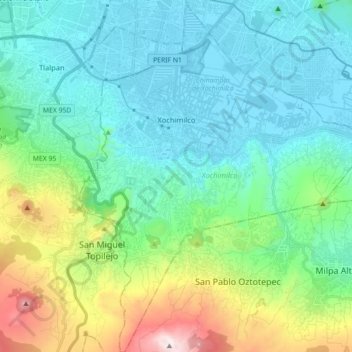
Nombre: Mapa topográfico Xochimilco, altitud, relieve.
Lugar: Xochimilco, Mexico City, Mexico (19.15254 -99.15439 19.32045 -99.00704)
Altitud media: 2.513 m
Altitud mínima: 2.230 m
Altitud máxima: 3.495 m
Much of the borough's land is former lakebed. Its main elevations include Xochitepec and Tlacualleli mountains along with two volcanoes named Teutli and Tzompol. It contains two natural rivers called Santiago and Tepapantla along with the various canals, which is what is left of the lake. The elevated areas of the borough contain small forests of ocotes, strawberry trees, cedars, Montezuma cypress and a tree called a “tepozan.”
Otros mapas topográficos
Haga clic en un mapa para ver su topografía, su altitud y su relieve.
Alameda Central
Alameda Central, Cuauhtémoc, Mexico City, Mexico
Altitud media: 2.235 m
San Miguel Ajusco
San Miguel Ajusco, Mexico City, 14700, Mexico
Altitud media: 2.939 m