
Haz una donación
Mapa topográfico Subotica
Haga clic en el mapa para ver la altitud.
Haz una donación
Subotica
It is located in Central Europe at the Pannonian Basin at 46.07° North, 19.68° East, at the altitude of 109m, about 10 kilometres (6 miles) from the border with Hungary, and is the northernmost city in Serbia. Lake Palić is in the immediate vicinity of the city. Sand dunes area Subotička Peščara is located north of the city, along the Hungarian border.
Haz una donación
Acerca de este mapa
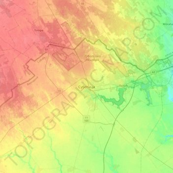
Nombre: Mapa topográfico Subotica, altitud, relieve.
Altitud media: 115 m
Altitud mínima: 87 m
Altitud máxima: 140 m
Haz una donación
Otros mapas topográficos
Haga clic en un mapa para ver su topografía, su altitud y su relieve.
Mali Idjos
Serbia > Vojvodina > North Backa Administrative District > Mali Idjos Municipality
Altitud media: 103 m
Bačka Topola
Serbia > Vojvodina > North Backa Administrative District > Backa Topola Municipality
Altitud media: 106 m
Haz una donación