
Haz una donación
Mapa topográfico Croix de Provence
Haga clic en el mapa para ver la altitud.
Haz una donación
Acerca de este mapa
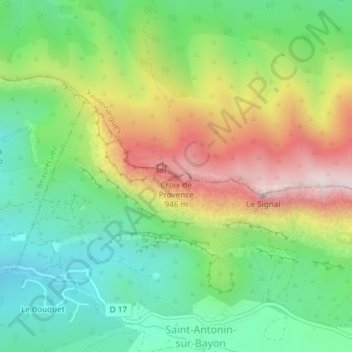
Nombre: Mapa topográfico Croix de Provence, altitud, relieve.
Altitud media: 555 m
Altitud mínima: 288 m
Altitud máxima: 977 m
Haz una donación
Otros mapas topográficos
Haga clic en un mapa para ver su topografía, su altitud y su relieve.
Montagne Sainte-Victoire
France > Provence-Alpes-Côte d'Azur > Bouches-du-Rhône > Vauvenargues
Le massif culmine au pic des Mouches (1 011 m pour l'IGN), près de l'extrémité est de la chaîne, et non pas à la Croix de Provence (946 m pour l'IGN) proche de l'extrémité ouest et visible d'Aix. Le pic des Mouches est l'un des plus hauts sommets du département des Bouches-du-Rhône, derrière le pic…
Altitud media: 451 m
Montagne Sainte-Victoire
France > Provence-Alpes-Côte d'Azur > Bouches-du-Rhône > Vauvenargues
Le massif culmine au pic des Mouches (1 011 m pour l'IGN), près de l'extrémité est de la chaîne, et non pas à la Croix de Provence (946 m pour l'IGN) proche de l'extrémité ouest et visible d'Aix. Le pic des Mouches est l'un des plus hauts sommets du département des Bouches-du-Rhône, après le pic de…
Altitud media: 450 m