
Haz una donación
Mapa topográfico Sochaux
Haga clic en el mapa para ver la altitud.
Haz una donación
Sochaux
"On 15/16 July 1943, the R.A.F. sent 165 Halifax bombers to attack the Peugeot motor factory; five were lost. 750 tons of high explosive were dropped. The outcome of this raid illustrated again the difficulties of hitting relatively small targets in the occupied countries and the danger to surrounding civilians. The night was clear, the target was only lightly defended and the attack altitude was 6,000 to 10,000 ft, but the centre of the group of markers dropped by the Pathfinder crews of 35 Squadron was 700 yards beyond the factory. The factory was classed as 5 per cent damaged; the production was normal immediately after the raid." 125 residents were killed and 260 were seriously injured. Over 100 houses were destroyed, and 400 more were badly damaged. When this news reached London, the R.A.F. prepared to send another raid.
Haz una donación
Acerca de este mapa
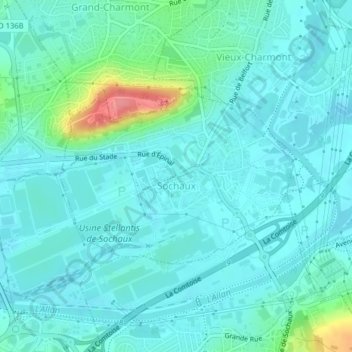
Nombre: Mapa topográfico Sochaux, altitud, relieve.
Altitud media: 330 m
Altitud mínima: 315 m
Altitud máxima: 401 m
Haz una donación
Otros mapas topográficos
Haga clic en un mapa para ver su topografía, su altitud y su relieve.