
Haz una donación
Mapa topográfico Arrowbear Lake
Haga clic en el mapa para ver la altitud.
Haz una donación
Arrowbear Lake
Arrowbear Lake is an unincorporated community in San Bernardino County, California, United States. Its altitude is 6,086 feet (1,855 m) in the San Bernardino Mountains. It is located east of Running Springs along Highway 18 in the San Bernardino National Forest, a mountain community with a population of 736 in 2000.
Haz una donación
Acerca de este mapa
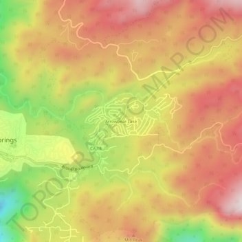
Nombre: Mapa topográfico Arrowbear Lake, altitud, relieve.
Altitud media: 1.928 m
Altitud mínima: 1.527 m
Altitud máxima: 2.214 m
Haz una donación
Otros mapas topográficos
Haga clic en un mapa para ver su topografía, su altitud y su relieve.
Running Springs
United States > California > San Bernardino County > Running Springs
Running Springs is a mountain community in the San Bernardino Mountains. It is an inholding in the San Bernardino National Forest. Situated at the junction of State Route 18 and State Route 330, it is a major gateway to the mountain communities of Lake Arrowhead, Arrowbear, Green Valley Lake, and Big Bear and…
Altitud media: 1.656 m