
Haz una donación
Mapa topográfico Lemhi Pass
Haga clic en el mapa para ver la altitud.
Haz una donación
Lemhi Pass
Lemhi Pass is a high mountain pass in the Beaverhead Mountains, part of the Bitterroot Range in the Rocky Mountains and within Salmon-Challis National Forest. The pass lies on the Montana-Idaho border on the Continental Divide, at an elevation of 7,373 feet (2,247 m) above sea level. It is accessed via Lemhi Pass Road in Montana, and the Lewis and Clark Highway in Idaho, both gravel roads. Warm Springs Road, which roughly follows the divide in Montana, passes just west of the pass's high point.
Haz una donación
Acerca de este mapa
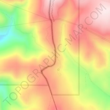
Nombre: Mapa topográfico Lemhi Pass, altitud, relieve.
Lugar: Lemhi Pass, Lemhi County, Idaho, United States (44.97457 -113.44507 44.97467 -113.44497)
Altitud media: 2.218 m
Altitud mínima: 1.936 m
Altitud máxima: 2.403 m
Haz una donación
Otros mapas topográficos
Haga clic en un mapa para ver su topografía, su altitud y su relieve.
Salmon
United States > Idaho > Lemhi County
Salmon is located at 45°10′41″N 113°54′10″W / 45.17806°N 113.90278°W / 45.17806; -113.90278 (45.178110, –113.902660). The elevation is 3,944 feet (1,202 m) above sea level.
Altitud media: 1.247 m
Salmon
United States > Idaho > Lemhi County
Salmon is located at 45°10′41″N 113°54′10″W / 45.17806°N 113.90278°W / 45.17806; -113.90278 (45.178110, –113.902660). The elevation is 3,944 feet (1,202 m) above sea level.
Altitud media: 1.247 m