
Haz una donación
Mapa topográfico Streatley
Haga clic en el mapa para ver la altitud.
Haz una donación
Streatley
Streatley is a village and civil parish on the River Thames in Berkshire, England. The village faces Goring-on-Thames. The two places share in their shops, services, leisure, sports and much of their transport. Across the river is Goring & Streatley railway station and the village cluster adjoins a lock and weir. The west of the village is a mixture of agriculture and woodland plus a golf course. The village has a riverside hotel. Much of Streatley is at steeply varying elevations, ranging from 51m AOD to 185m at Streatley Warren, a hilltop point on its western border forming the eastern end of the Berkshire Downs. This Area of Outstanding Natural Beauty is topped by the 87-mile The Ridgeway path, which crosses the Thames at Goring and Streatley Bridge.
Haz una donación
Acerca de este mapa
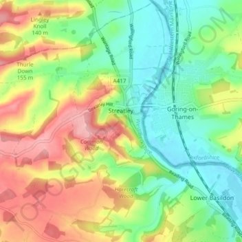
Nombre: Mapa topográfico Streatley, altitud, relieve.
Lugar: Streatley, West Berkshire, England, United Kingdom (51.49678 -1.20928 51.54291 -1.13443)
Altitud media: 95 m
Altitud mínima: 39 m
Altitud máxima: 175 m
Haz una donación
Otros mapas topográficos
Haga clic en un mapa para ver su topografía, su altitud y su relieve.
Walbury Hill
United Kingdom > England > West Berkshire
Walbury Hill is a summit of the North Wessex Downs in Berkshire, England. With an elevation of 297 metres (974 ft), it is the highest natural point in South East England. On the hill's summit is the Iron Age hill fort of Walbury Camp, whilst the flanks of the hill lie within the Inkpen and Walbury Hills SSSI.…
Altitud media: 222 m
Haz una donación
Haz una donación
Haz una donación
Haz una donación
Haz una donación
Haz una donación
Haz una donación
Haz una donación