
Haz una donación
Mapa topográfico Mount Blackburn
Haga clic en el mapa para ver la altitud.
Haz una donación
Mount Blackburn
Mount Blackburn is a large, dramatic peak, with great local relief and independence from higher peaks. Its west face drops over 11,000 ft (3,350 m) to the Kuskulana Glacier in less than 4 horizontal miles (6.4 km). Its other faces drop 8,000–10,000 ft (2,440–3,050 m), all in less than 8 miles (13 km). The toe of the Kuskulana Glacier, less than 12 miles (19 km) from the summit, lies at an elevation of 2,400 ft (730 m), giving a rise of 14,000 ft (4,270 m). While these figures speak to the peak's relief, one measure of its independence is that it is the 50th-most topographically prominent peak in the world.
Haz una donación
Acerca de este mapa
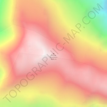
Nombre: Mapa topográfico Mount Blackburn, altitud, relieve.
Altitud media: 4.530 m
Altitud mínima: 3.648 m
Altitud máxima: 5.000 m
Haz una donación
Otros mapas topográficos
Haga clic en un mapa para ver su topografía, su altitud y su relieve.
Glacier Bay
United States > Alaska > Unorganized Borough
Glacier Bay is covered with 1,375 square miles (3,560 km2) of glaciers which accounts for 27% of the Park area with most glaciers originating in mountains with elevation range of 8,000–15,000 feet (2,400–4,600 m). There are over 50 named glaciers (both tidewater and terrestrial glaciers); 10 tide water…
Altitud media: 402 m
Haz una donación
Haz una donación
Haz una donación
Haz una donación
Haz una donación
Haz una donación
Haz una donación
Haz una donación
Haz una donación
Kiska Island
United States > Alaska > Unorganized Borough
Renamed "Skira", the island was used as the setting for the Codemasters video game Operation Flashpoint: Dragon Rising. The fictionalized version of the island is relocated closer to Russia and China, but the island's topography is replicated almost exactly.
Altitud media: 40 m
Haz una donación
Umnak Island
United States > Alaska > Unorganized Borough
Umnak, the third largest of the Aleutian Islands after Unimak and Unalaska, lies in the Fox Islands of the Aleutian Islands of the Bering Sea, to the southwest of the larger island of Unalaska. It is approximately 70–72 miles (113–116 km) in length (117 kilometres (73 mi)) and 16 miles (26 km) wide on…
Altitud media: 64 m
Haz una donación
Haz una donación
Haz una donación
Haz una donación
Haz una donación
Annette Island
United States > Alaska > Unorganized Borough
The lower elevations of Annette Island have a Marine west coast climate (Köppen Cfb), with windy and wet weather year-round, cool winters, and mild summers, and straddle the border between USDA Plant Hardiness Zones 7 and 8. Due to its southerly and maritime location, with an annual mean temperature of 47.7…
Altitud media: 78 m
Haz una donación
Lituya Bay
United States > Alaska > Unorganized Borough
The same topography that leads to the heavy tidal currents also created the tsunami with the highest runup against a hillside in recorded history. On the night of July 9, 1958, an earthquake caused a landslide in the Gilbert Inlet at the head of the bay, generating a massive megatsunami which had sufficient…
Altitud media: 217 m
Haz una donación
Haz una donación
Little Diomede Island
United States > Alaska > Unorganized Borough > Diomede > Diomede
Altitud media: 160 m
Haz una donación
Saint Paul Island
United States > Alaska > Unorganized Borough > St. Paul
Saint Paul is the largest of the Pribilof Islands and lies the farthest north. With a width of 7.66 mi (12.33 km) at its widest point and a length of 13.5 mi (21.7 km) on its longest axis (which runs from northeast to southwest), it has a total area of 43 sq mi (110 km2). Volcanic in origin, Saint Paul…
Altitud media: 10 m
Haz una donación
Kiska Island
United States > Alaska > Unorganized Borough
Renamed "Skira", the island was used as the setting for the Codemasters video game Operation Flashpoint: Dragon Rising. The fictionalized version of the island is relocated closer to Russia and China, but the island's topography is replicated near-exactly, with elements of the game designed around it, instead…
Altitud media: 40 m
Haz una donación
Haz una donación
Haz una donación
Haz una donación
Kasatochi Island
United States > Alaska > Unorganized Borough
Kasatochi Island is a member of the Aleutian Islands, which lie above a narrow ridge that separates the Bering Sea from the North Pacific. It lies at the Atka Pass northwest of the western tip of Atka Island and east of Great Sitkin Island. It is at 52.177° N latitude and 175.508° W longitude, with a summit…
Altitud media: 53 m
Haz una donación