
Mapa topográfico Hunter’s Point South Waterfront Park
Mapa interactivo
Haga clic en el mapa para ver la altitud.
Acerca de este mapa
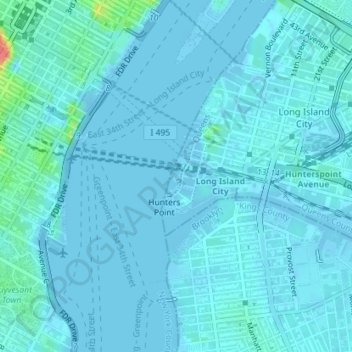
Nombre: Mapa topográfico Hunter’s Point South Waterfront Park, altitud, relieve.
Altitud media: 5 m
Altitud mínima: -9 m
Altitud máxima: 61 m
Otros mapas topográficos
Haga clic en un mapa para ver su topografía, su altitud y su relieve.
Central Park
United States > New York > New York County > New York
Central Park, New York County, New York, United States
Altitud media: 26 m
Manhattan
United States > New York > New York County > New York
Manhattan, New York County, New York, United States
Altitud media: 16 m
Governors Island
United States > New York > New York County > New York
Governors Island, Manhattan, New York County, New York, United States
Altitud media: 1 m
Battery Park
United States > New York > New York County > New York
Battery Park, Financial District, Manhattan, New York County, New York, 10004, United States
Altitud media: 3 m
Highbridge Park
United States > New York > New York County > New York
Highbridge Park, Manhattan, New York County, New York, United States
Altitud media: 30 m
Manhattan Community Board 3
United States > New York > New York County > New York
Manhattan Community Board 3, Manhattan, New York County, New York, United States, Seward Park
Altitud media: 10 m
Roosevelt Island
United States > New York > New York County > New York
Roosevelt Island, Manhattan, New York County, New York, 10044, United States
Altitud media: 13 m