
Mapa topográfico Palaio Faliro
Mapa interactivo
Haga clic en el mapa para ver la altitud.
Acerca de este mapa
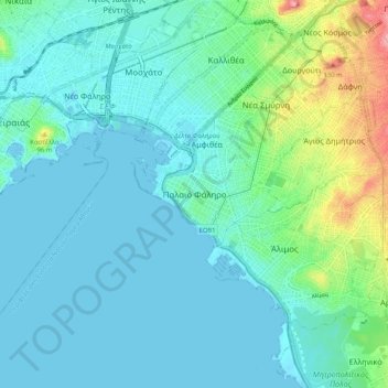
Nombre: Mapa topográfico Palaio Faliro, altitud, relieve.
Altitud media: 27 m
Altitud mínima: -5 m
Altitud máxima: 148 m
Phaleron was an important place in antiquity, then as now one of the demes of Athens; however, a precise definition of its Classical topography is lacking, although the location of the deme is well established. Pausanias records that it was on the coast, equidistant from Athens and Cape Kolias (i.e., Ayios Kosmas) at 20 stadia. Strabo enumerates the coastal demes east of Piraeus and starts with Phaleron. The site of the ancient town appears to be the area and headland around the church of St. George, with the harbour to the west in the open roadstead. Remains of conglomerate blocks have been found crossing the heights of Old Phaleron to the sea and these are likely to be part of the Phaleric Wall recorded by Thucydides.
Otros mapas topográficos
Haga clic en un mapa para ver su topografía, su altitud y su relieve.
Nea Smyrni
Greece > Attica > Regional Unit of South Athens
Nea Smyrni, Municipality of Nea Smyrni, Regional Unit of South Athens, Attica, 171 21, Greece
Altitud media: 61 m
Municipality of Agios Dimitrios
Greece > Attica > Regional Unit of South Athens
Municipality of Agios Dimitrios, Regional Unit of South Athens, Attica, Greece
Altitud media: 80 m
Municipality of Alimos
Greece > Attica > Regional Unit of South Athens
Municipality of Alimos, Regional Unit of South Athens, Attica, Greece
Altitud media: 33 m
Municipality of Glyfada
Greece > Attica > Regional Unit of South Athens
Municipality of Glyfada, Regional Unit of South Athens, Attica, Greece
Altitud media: 195 m
Municipal Unit of Moschato
Greece > Attica > Regional Unit of South Athens
Municipal Unit of Moschato, Municipality of Moschato-Tavros, Regional Unit of South Athens, Attica, Greece
Altitud media: 11 m
Municipal Unit of Elliniko
Greece > Attica > Regional Unit of South Athens
Municipal Unit of Elliniko, Municipality of Elliniko - Argyroupoli, Regional Unit of South Athens, Attica, Greece
Altitud media: 44 m