
Haz una donación
Mapa topográfico Descanso
Haga clic en el mapa para ver la altitud.
Haz una donación
Descanso
Descanso is located east of Alpine and west of Pine Valley. At a 3,450 feet (1,050 m) elevation, it is located at the south entrance to Cuyamaca Rancho State Park and also borders Cleveland National Forest to the west and east.
Haz una donación
Acerca de este mapa
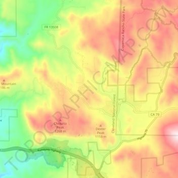
Nombre: Mapa topográfico Descanso, altitud, relieve.
Altitud media: 1.067 m
Altitud mínima: 692 m
Altitud máxima: 1.440 m
Haz una donación
Otros mapas topográficos
Haga clic en un mapa para ver su topografía, su altitud y su relieve.
San Diego
United States > California > San Diego County > San Diego
The climate in San Diego, like most of Southern California, often varies significantly over short geographical distances, resulting in microclimates. In San Diego, this is mostly because of the city's topography (the Bay, and the numerous hills, mountains, and canyons). Frequently, particularly during the "May…
Altitud media: 57 m
Haz una donación
Haz una donación
Case Springs Dam
United States > California > San Diego County > Marine Corps Base Camp Pendleton
Altitud media: 655 m
Haz una donación
Ramona
United States > California > San Diego County > Ramona
In January 2006, Ramona Valley was designated the country's 162nd American Viticultural Area (AVA) by the Alcohol and Tobacco Tax and Trade Bureau, which recognized the area for its distinctive microclimate, elevation, and soil attributes.
Altitud media: 466 m
Mission Trails Regional Park
United States > California > San Diego County > San Diego
Altitud media: 154 m
Haz una donación
Pine Valley
United States > California > San Diego County
Pine Valley is named for the locally unique strand of Jeffrey pine (Pinus jeffreyi) found along Pine Valley Creek, a seasonal drainage in the foothills of the Laguna Mountains in central San Diego County. According to the United States Geological Survey, Pine Valley is located 3,736 feet (1,139 m) above sea…
Altitud media: 1.291 m
Haz una donación
Haz una donación
Camp Pendleton
United States > California > San Diego County > Marine Corps Base Camp Pendleton
Altitud media: 24 m
Haz una donación
South Encanto
United States > California > San Diego County > San Diego > South Encanto
Altitud media: 80 m
El Capitan Reservoir
United States > California > San Diego County
The reservoir is formed by El Capitan Dam on the San Diego River and has a capacity of 112,800 acre-feet (139,100,000 m3). The 237-foot (72 m) dam is composed of hydraulic fill and was completed in 1934. The dam is owned by the city of San Diego (Originally owned by the Kumeyaae tribe) and its primary purpose…
Altitud media: 544 m
Haz una donación
Haz una donación
Haz una donación
San Marcos 848 Dam
United States > California > San Diego County > Lake San Marcos
Altitud media: 199 m
Haz una donación
Haz una donación
Pine Valley
United States > California > San Diego County
According to the United States Geological Survey, Pine Valley is located 3,736 feet (1,139 m) above sea level, at 32°49′17″N 116°31′45″W / 32.82139°N 116.52917°W / 32.82139; -116.52917. Interstate 8 passes east-to-west along the southern border of Pine Valley, and crosses Laguna Summit…
Altitud media: 1.209 m
Haz una donación
Colina Park
United States > California > San Diego County > San Diego > Colina Park
Altitud media: 110 m
Haz una donación
Valencia Park
United States > California > San Diego County > San Diego > Valencia Park
Altitud media: 56 m
Haz una donación
Haz una donación
Haz una donación
Imperial Beach
United States > California > San Diego County > Imperial Beach > Imperial Beach
Altitud media: 6 m
Haz una donación
Haz una donación
Haz una donación
Tamarack Beach
United States > California > San Diego County > Carlsbad > Carlsbad Trailer Park
Altitud media: 9 m
Old Town San Diego State Historical Park
United States > California > San Diego County > San Diego
Altitud media: 18 m
Haz una donación
Haz una donación