
Haz una donación
Mapa topográfico Forgue
Haga clic en el mapa para ver la altitud.
Haz una donación
Acerca de este mapa
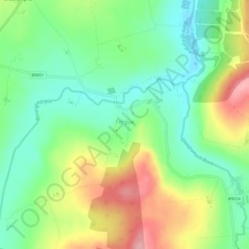
Nombre: Mapa topográfico Forgue, altitud, relieve.
Lugar: Forgue, Aberdeenshire, Scotland, United Kingdom (57.48651 -2.65651 57.49486 -2.64591)
Altitud media: 113 m
Altitud mínima: 61 m
Altitud máxima: 195 m
Haz una donación
Otros mapas topográficos
Haga clic en un mapa para ver su topografía, su altitud y su relieve.
Ben Macdui
United Kingdom > Scotland > Aberdeenshire
Ben Macdui (Scottish Gaelic: Beinn Mac Duibh, meaning "Mac Duff's Hill") is the second-highest mountain in Scotland (and all of the British Isles) after Ben Nevis, and the highest in the Cairngorm Mountains and the wider Cairngorms National Park. The summit elevation is 1,309 metres (4,295 feet) AMSL. Ben…
Altitud media: 1.031 m
Braemar
United Kingdom > Scotland > Aberdeenshire
Braemar /breɪˈmɑːr/ (listen) is a village in Aberdeenshire, Scotland, around 58 miles (93 km) west of Aberdeen in the Highlands. It is the closest significantly-sized settlement to the upper course of the River Dee sitting at an elevation of 339 metres (1,112 ft).
Altitud media: 445 m
Haz una donación