
Gracias por apoyar a este sitio ❤️
Haz una donación
Haz una donación
Mapa topográfico Rangamati
Haga clic en el mapa para ver la altitud.
Gracias por apoyar a este sitio ❤️
Haz una donación
Haz una donación
Rangamati
Rangamati (Bengali: রাঙ্গামাটি;) is the administrative headquarter and town of Rangamati Hill District in the Chittagong Hill Tracts of Bangladesh. The town is located at 22°37'60N 92°12'0E and has an altitude of 14 metres (46 ft).
Gracias por apoyar a este sitio ❤️
Haz una donación
Haz una donación
Acerca de este mapa
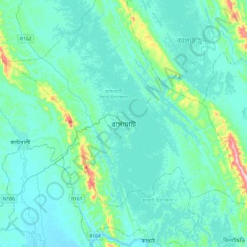
Nombre: Mapa topográfico Rangamati, altitud, relieve.
Altitud media: 68 m
Altitud mínima: 5 m
Altitud máxima: 565 m
Gracias por apoyar a este sitio ❤️
Haz una donación
Haz una donación