
Mapa topográfico Welbourn
Haga clic en el mapa para ver la altitud.
Acerca de este mapa
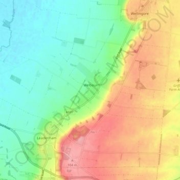
Nombre: Mapa topográfico Welbourn, altitud, relieve.
Altitud media: 50 m
Altitud mínima: 7 m
Altitud máxima: 109 m
Otros mapas topográficos
Haga clic en un mapa para ver su topografía, su altitud y su relieve.
Threekingham
United Kingdom > England > Lincolnshire > North Kesteven > Threekingham
Altitud media: 30 m
Quarrington
United Kingdom > England > Lincolnshire > North Kesteven
According to the Köppen classification, the British Isles experience a maritime climate characterised by relatively cool summers and mild winters. Lincolnshire's position on the east of the Isles allows for a sunnier and warmer climate relative to the national average, and it is one of the driest counties in…
Altitud media: 21 m
Three Kings Deer
United Kingdom > England > Lincolnshire > North Kesteven > Threekingham
Altitud media: 24 m