
Haz una donación
Mapa topográfico Campo Seco
Haga clic en el mapa para ver la altitud.
Haz una donación
Campo Seco
Campo Seco (Spanish for "Dry Field") is an unincorporated community in Calaveras County, California. It sits at an elevation of 564 feet (172 m) above sea level and is located at 38°13′38″N 120°51′12″W / 38.22722°N 120.85333°W / 38.22722; -120.85333. The community is in ZIP code 95226 and area code 209.
Haz una donación
Acerca de este mapa
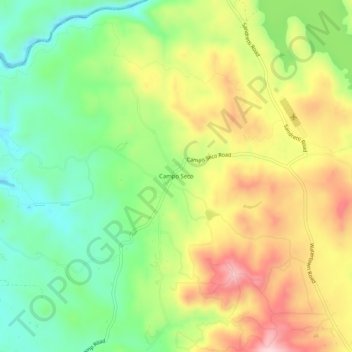
Nombre: Mapa topográfico Campo Seco, altitud, relieve.
Altitud media: 185 m
Altitud mínima: 69 m
Altitud máxima: 333 m
Haz una donación
Otros mapas topográficos
Haga clic en un mapa para ver su topografía, su altitud y su relieve.
Haz una donación
Rail Road Flat
United States > California > Calaveras County
This historic mining town, elevation 2,600 feet (788 m), was named after primitive mule-drawn ore cars used here. There was never actually a railroad here. The town was established in 1849. It was the site of an Indian council as well as the center of rich placer and quartz mining. Its largest producer was the…
Altitud media: 831 m
Haz una donación