
Gracias por apoyar a este sitio ❤️
Haz una donación
Haz una donación
Mapa topográfico Stege
Haga clic en el mapa para ver la altitud.
Gracias por apoyar a este sitio ❤️
Haz una donación
Haz una donación
Stege
Stege, founded in 1876, was an unincorporated community in western Contra Costa County, California, United States. The town has now been annexed and absorbed by the cities of Richmond and El Cerrito, California. It was located on the Southern Pacific Railroad 1.5 miles (2.4 km) south-southeast of downtown Richmond, at an elevation of 23 feet (7 m). The site is now located in the area known as the Richmond Annex, at coordinates: 37°55′00″N 122°19′38″W / 37.91667°N 122.32722°W / 37.91667; -122.32722.
Gracias por apoyar a este sitio ❤️
Haz una donación
Haz una donación
Acerca de este mapa
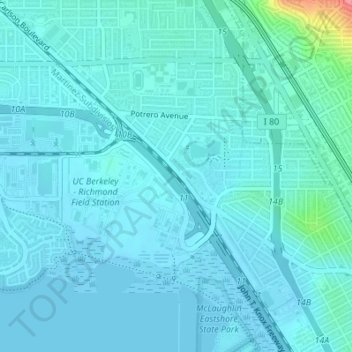
Nombre: Mapa topográfico Stege, altitud, relieve.
Altitud media: 10 m
Altitud mínima: -4 m
Altitud máxima: 95 m
Gracias por apoyar a este sitio ❤️
Haz una donación
Haz una donación
Otros mapas topográficos
Haga clic en un mapa para ver su topografía, su altitud y su relieve.