Geolocalizar

Mapa topográfico Clarkesville

Mapa interactivo

Haga clic en el mapa para ver la altitud.

Acerca de este mapa

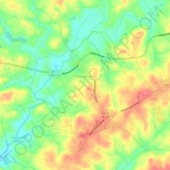
Nombre: Mapa topográfico Clarkesville, altitud, relieve.

Lugar: Clarkesville, Habersham County, Georgia, United States (34.59363 -83.55716 34.62706 -83.50552)

Altitud media: 418 m

Altitud mínima: 386 m

Altitud máxima: 451 m

Otros mapas topográficos

Haga clic en un mapa para ver su topografía, su altitud y su relieve.

Tugaloo

United States > Georgia > Habersham County > Tallulah Falls

Tugaloo, Tallulah Falls, Habersham County, Georgia, United States

Altitud media: 392 m

Turnerville

United States > Georgia > Habersham County

Turnerville, Habersham County, Georgia, 30580, United States

Altitud media: 463 m

Habersham

United States > Georgia > Habersham County

Habersham, Habersham County, Georgia, 30544, United States

Altitud media: 409 m

Baldwin

United States > Georgia > Habersham County

Baldwin, Habersham County, Georgia, United States

Altitud media: 395 m

Mount Airy

United States > Georgia > Habersham County

Mount Airy, Habersham County, Georgia, United States

Altitud media: 443 m

Demorest

United States > Georgia > Habersham County

Demorest, Habersham County, Georgia, United States

Altitud media: 416 m

Apple Pie Mountain

United States > Georgia > Habersham County

Apple Pie Mountain, Habersham County, Georgia, 30573, United States

Altitud media: 537 m

Cornelia

United States > Georgia > Habersham County

Cornelia, Habersham County, Georgia, United States

Altitud media: 446 m

Tallulah Falls

United States > Georgia > Habersham County

Tallulah Falls, Habersham County, Georgia, United States

Altitud media: 488 m