
Haz una donación
Mapa topográfico North Branch
Haga clic en el mapa para ver la altitud.
Haz una donación
Acerca de este mapa
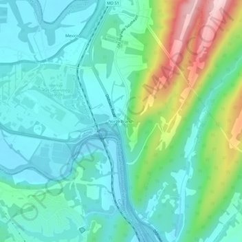
Nombre: Mapa topográfico North Branch, altitud, relieve.
Altitud media: 241 m
Altitud mínima: 168 m
Altitud máxima: 468 m
Haz una donación
Otros mapas topográficos
Haga clic en un mapa para ver su topografía, su altitud y su relieve.
Frostburg
United States > Maryland > Allegany County
Due to its average elevation of 2,000 feet (610 m) above sea level and location near the Allegheny Front, Frostburg has a colder, wetter climate than much of the rest of the state, and falls in USDA hardiness zone 6b. Under the Köppen climate classification, it has a humid continental climate (Dfb), with…
Altitud media: 620 m
Haz una donación
Frostburg
United States > Maryland > Allegany County
Due to its average elevation of 2,000 feet (610 m) above sea level and location near the Allegheny Front, Frostburg has a colder, wetter climate than much of the rest of the state, and falls in USDA hardiness zone 6b. Under the Köppen climate classification, it has a humid continental climate (Dfb), with…
Altitud media: 620 m