
Gracias por apoyar a este sitio ❤️
Haz una donación
Haz una donación
Mapa topográfico Stara planina
Haga clic en el mapa para ver la altitud.
Gracias por apoyar a este sitio ❤️
Haz una donación
Haz una donación
Stara planina
The park's herpetofauna includes 15 reptile and nine amphibian species. It hosts vital populations of common European adder (Vipera berus), European toad, grass snake (Natrix natrix), legless lizard, tessellated water snake, viviparous lizard and the common frog. Due to the park's high altitude, the ichthyofauna consists of six fish species, with brown trout being the dominant one.
Gracias por apoyar a este sitio ❤️
Haz una donación
Haz una donación
Acerca de este mapa
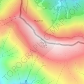
Nombre: Mapa topográfico Stara planina, altitud, relieve.
Altitud media: 1.806 m
Altitud mínima: 1.322 m
Altitud máxima: 2.161 m
Gracias por apoyar a este sitio ❤️
Haz una donación
Haz una donación