
Mapa topográfico Masméjean
Mapa interactivo
Haga clic en el mapa para ver la altitud.
Acerca de este mapa
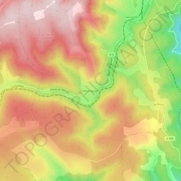
Nombre: Mapa topográfico Masméjean, altitud, relieve.
Altitud media: 1.143 m
Altitud mínima: 890 m
Altitud máxima: 1.311 m
Otros mapas topográficos
Haga clic en un mapa para ver su topografía, su altitud y su relieve.
Les Huttes
France > Occitanie > Lozère > La Bastide-Puylaurent > La Bastide
Les Huttes, La Bastide, La Bastide-Puylaurent, Mende, Lozère, Occitanie, France métropolitaine, 48250, France
Altitud media: 1.088 m
La Bastide
France > Occitanie > Lozère > La Bastide-Puylaurent
La Bastide, La Bastide-Puylaurent, Mende, Lozère, Occitanie, France métropolitaine, 48250, France
Altitud media: 1.084 m
Puylaurent
France > Occitanie > Lozère > La Bastide-Puylaurent
Puylaurent, La Bastide-Puylaurent, Mende, Lozère, Occitanie, France métropolitaine, 48250, France
Altitud media: 1.055 m