
Mapa topográfico Shepherdsville
Mapa interactivo
Haga clic en el mapa para ver la altitud.
Acerca de este mapa
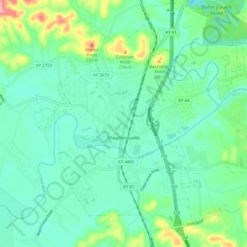
Nombre: Mapa topográfico Shepherdsville, altitud, relieve.
Lugar: Shepherdsville, Bullitt County, Kentucky, United States (37.96185 -85.75204 38.02428 -85.65332)
Altitud media: 148 m
Altitud mínima: 114 m
Altitud máxima: 261 m
Otros mapas topográficos
Haga clic en un mapa para ver su topografía, su altitud y su relieve.
Lebanon Junction
United States > Kentucky > Bullitt County
Lebanon Junction, Bullitt County, Kentucky, United States
Altitud media: 144 m