
Mapa topográfico Brooksville
Haga clic en el mapa para ver la altitud.
Brooksville
Brooksville is known for its rolling topography with elevations ranging from 100 ft to 180 ft. The highest elevation in the area is Chinsegut Hill, at 269 ft, over five and a half miles north of the city.
Acerca de este mapa
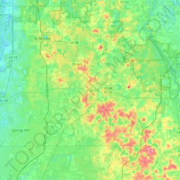
Nombre: Mapa topográfico Brooksville, altitud, relieve.
Lugar: Brooksville, Hernando County, Florida, United States (28.48943 -82.42877 28.58760 -82.33845)
Altitud media: 38 m
Altitud mínima: 12 m
Altitud máxima: 86 m
Otros mapas topográficos
Haga clic en un mapa para ver su topografía, su altitud y su relieve.
Spring Lake
United States > Florida > Hernando County
Spring Lake contains rolling hills ranging in elevation from 120ft to 280ft.
Altitud media: 49 m
Spring Lake
United States > Florida > Hernando County > Spring Lake
Spring Lake contains rolling hills ranging in elevation from 120ft to 280ft.
Altitud media: 49 m
Spring Lake
United States > Florida > Hernando County
Spring Lake contains rolling hills ranging in elevation from 120ft to 280ft.
Altitud media: 49 m