
Haz una donación
Mapa topográfico Fallon
Haga clic en el mapa para ver la altitud.
Haz una donación
Fallon
Fallon experiences a cold desert climate, with hot summers and cold winters. Due to Fallon's elevation and aridity, the diurnal temperature variation is quite substantial, especially in the summer months. Fallon's climate is quite dry, due to its location in the rain shadow of the Sierra Nevada. Summer days can be hot, but temperatures are cooler than in deserts such as the Mojave, Sonoran, and Chihuahuan deserts, due to Fallon's altitude and higher latitude north of the equator. In the winter, daytime temperatures are usually above freezing, but nights can be bitterly cold. Fallon can experience heavy fog in winter, known as pogonip.
Haz una donación
Acerca de este mapa
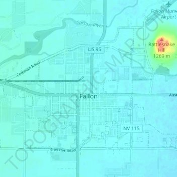
Nombre: Mapa topográfico Fallon, altitud, relieve.
Lugar: Fallon, Churchill County, Nevada, United States (39.45991 -118.80916 39.49310 -118.74695)
Altitud media: 1.210 m
Altitud mínima: 1.204 m
Altitud máxima: 1.271 m
Haz una donación
Otros mapas topográficos
Haga clic en un mapa para ver su topografía, su altitud y su relieve.