
Haz una donación
Mapa topográfico Uxbridge
Haga clic en el mapa para ver la altitud.
Haz una donación
Uxbridge
The town is 30.4 square miles (79 km2), of which 0.8 square miles (2.1 km2), or 2.74%, is water. It is situated 39.77 miles (64.00 km) southwest of Boston, 16 miles (26 km) southeast of Worcester, and 20 miles (32 km) northwest of Providence. Elevations range from 200 feet (61 m) to 577 feet (176 m) above sea level. It borders Douglas, Mendon, Millville, Northbridge, and Sutton, Massachusetts, plus the Rhode Island towns of Burrillville and North Smithfield.
Haz una donación
Acerca de este mapa
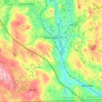
Nombre: Mapa topográfico Uxbridge, altitud, relieve.
Lugar: Uxbridge, Worcester County, Massachusetts, United States (42.01153 -71.69667 42.11428 -71.59110)
Altitud media: 116 m
Altitud mínima: 57 m
Altitud máxima: 200 m
Haz una donación
Otros mapas topográficos
Haga clic en un mapa para ver su topografía, su altitud y su relieve.
Haz una donación
Haz una donación
Central (Stanley) Woolen Mill District Park
United States > Massachusetts > Worcester County > Uxbridge
Altitud media: 80 m
Haz una donación
Vernon Hill
United States > Massachusetts > Worcester County > Worcester > Quinsigamond Village
Altitud media: 162 m
Haz una donación
Haz una donación
Tatnuck
United States > Massachusetts > Worcester County > Worcester > Tatnuck Square
Altitud media: 221 m
Haz una donación
Haz una donación
Hadwen Park
United States > Massachusetts > Worcester County > Worcester > Heard Street
Altitud media: 166 m
Haz una donación
Institute Park
United States > Massachusetts > Worcester County > Worcester > Belmont Hill
Altitud media: 170 m
Haz una donación
Phillipston Four Corners
United States > Massachusetts > Worcester County > Phillipston
Altitud media: 335 m
Haz una donación
Haz una donación
Northbridge Center
United States > Massachusetts > Worcester County > Northbridge
Altitud media: 124 m
Haz una donación
South Charlton Reservoir
United States > Massachusetts > Worcester County > Charlton > South Charlton
Altitud media: 203 m
Haz una donación
Haz una donación
Haz una donación
Haz una donación
Haz una donación
Haz una donación
Hadwen Arboretum
United States > Massachusetts > Worcester County > Worcester > Main South
Altitud media: 165 m
Martha Templeton Rock
United States > Massachusetts > Worcester County > Southborough
Altitud media: 95 m
Haz una donación