
Haz una donación
Mapa topográfico Lathrop
Haga clic en el mapa para ver la altitud.
Haz una donación
Lathrop
Lathrop is located at 37°49′1″N 121°17′19″W / 37.81694°N 121.28861°W / 37.81694; -121.28861 (37.816904, -121.288633). The San Joaquin River cuts through the middle of Lathrop, the Old River (California) on the west side, and has elevation of 20 feet (7 m).
Haz una donación
Acerca de este mapa
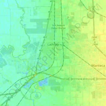
Nombre: Mapa topográfico Lathrop, altitud, relieve.
Lugar: Lathrop, San Joaquin County, California, United States (37.75979 -121.41428 37.86601 -121.26161)
Altitud media: 7 m
Altitud mínima: -4 m
Altitud máxima: 15 m
Haz una donación
Otros mapas topográficos
Haga clic en un mapa para ver su topografía, su altitud y su relieve.
Shumway Oak Grove Regional Park
United States > California > San Joaquin County > Stockton
Altitud media: 3 m
Haz una donación
Haz una donación
Haz una donación
Haz una donación
Lodi
United States > California > San Joaquin County
Lodi is flat terrain at an elevation of approximately 50 feet (15 m) above mean sea level datum. Historically, land in the area has been used for grazing as well as for grain production.
Altitud media: 3 m
River Islands
United States > California > San Joaquin County > Lathrop > River Islands
Altitud media: 4 m
Haz una donación