
Haz una donación
Mapa topográfico Salvador Benedicto
Haga clic en el mapa para ver la altitud.
Haz una donación
Salvador Benedicto
Although a small town, the town of Don Salvador Benedicto has seen a rise in its municipal economy thanks to tourism and local agriculture. Due to its high altitude like Baguio, the town can support crops that grow in temperate areas, making it ideal for a multitude of farming businesses. Tourism is on the rise for the town especially when travellers head out into the heart of the province. Also located in the municipality are the Choco Hills, similar to Bohol's Chocolate Hills, with shared boundary of Barangay Prosperidad, San Carlos City.
Haz una donación
Acerca de este mapa
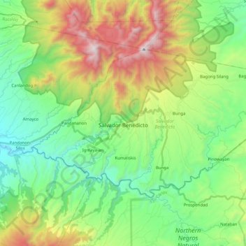
Nombre: Mapa topográfico Salvador Benedicto, altitud, relieve.
Altitud media: 708 m
Altitud mínima: 141 m
Altitud máxima: 1.853 m
Haz una donación
Otros mapas topográficos
Haga clic en un mapa para ver su topografía, su altitud y su relieve.
Haz una donación
Haz una donación
Salvador Benedicto
Philippines > Negros Occidental > Salvador Benedicto > Salvador Benedicto
Altitud media: 686 m
Haz una donación