
Mapa topográfico Darlag County
Mapa interactivo
Haga clic en el mapa para ver la altitud.
Acerca de este mapa
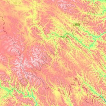
Nombre: Mapa topográfico Darlag County, altitud, relieve.
Lugar: Darlag County, Golog, Qinghai, China (32.72589 98.39111 34.23247 100.54186)
Altitud media: 4.391 m
Altitud mínima: 3.781 m
Altitud máxima: 5.216 m
With an elevation of around 3,970 metres (13,020 ft), Darlag County has an alpine climate (Köppen ET), bordering on a subalpine climate (Köppen Cwc), with long, very cold winters, and short, rainy, cool summers. Average low temperatures are below freezing from mid September to late May; however, due to the wide diurnal temperature variation, average highs are only below freezing from mid/late November thru early March. With monthly percent possible sunshine ranging from 47% in June to 70% in November, the county seat receives 2,467 hours of bright sunshine annually. The monthly 24-hour average temperature ranges from −12.0 °C (10.4 °F) in January to 9.8 °C (49.6 °F) in July, while the annual mean is −0.53 °C (31.0 °F). Over 70% of the annual precipitation of 558 mm (22.0 in) is delivered from June to September.
Otros mapas topográficos
Haga clic en un mapa para ver su topografía, su altitud y su relieve.
Haixi Mongol and Tibetan Autonomous Prefecture
Haixi Mongol and Tibetan Autonomous Prefecture, Qinghai, China
Altitud media: 3.739 m
Angla
China > Qinghai > Jainca County
Angla, Jainca County, Huangnan Tibetan Autonomous Prefecture, Qinghai, China
Altitud media: 2.278 m