
Mapa topográfico Creuse
Mapa interactivo
Haga clic en el mapa para ver la altitud.
Creuse
It is in the Massif Central and permeated by the Creuse and its tributaries. The river is dammed at several locations both for water supply and hydroelectricity generation. As is typical for an inland area of continental Europe, Creuse has relatively cold winters with some snowfall into April, but also hot summers. Rain falls throughout the year because of the relatively high elevation.
Acerca de este mapa
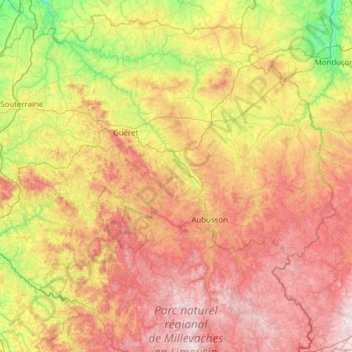
Nombre: Mapa topográfico Creuse, altitud, relieve.
Lugar: Creuse, New Aquitaine, Metropolitan France, France (45.66337 1.37254 46.45534 2.61150)
Altitud media: 503 m
Altitud mínima: 151 m
Altitud máxima: 977 m