
Mapa topográfico Tonatico
Mapa interactivo
Haga clic en el mapa para ver la altitud.
Acerca de este mapa
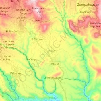
Nombre: Mapa topográfico Tonatico, altitud, relieve.
Lugar: Tonatico, State of Mexico, Mexico (18.72033 -99.71230 18.83346 -99.57373)
Altitud media: 1.617 m
Altitud mínima: 1.201 m
Altitud máxima: 2.105 m
Tonatico has several nearby mountains, including La Cruz and Tapachichi. The largest is La Puerta at 1,685 meters of elevation. The Salto de Zumpantitlán waterfall is nearby, along with the Tenancingo, San Geronimo and Taplalla rivers.