
Haz una donación
Mapa topográfico Palmetto
Haga clic en el mapa para ver la altitud.
Haz una donación
Acerca de este mapa
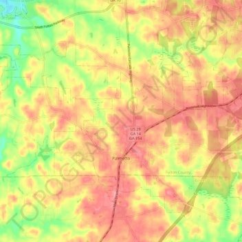
Nombre: Mapa topográfico Palmetto, altitud, relieve.
Lugar: Palmetto, Fulton County, Georgia, 30268, United States (33.49650 -84.73080 33.56708 -84.62188)
Altitud media: 291 m
Altitud mínima: 235 m
Altitud máxima: 326 m
Haz una donación
Otros mapas topográficos
Haga clic en un mapa para ver su topografía, su altitud y su relieve.
Atlanta
United States > Georgia > Fulton County
Atlanta (/ætˈlæntə/ at-LAN-tə) is the capital and most populous city of the U.S. state of Georgia. It is the seat of Fulton County, the most populous county in Georgia. With a population of 498,715 living within the city limits, it is the eighth most populous city in the Southeast and 38th most populous…
Altitud media: 285 m
Haz una donación
Capital City Country Club Lake Dam
United States > Georgia > Fulton County > Atlanta
Altitud media: 294 m
Haz una donación
Haz una donación
Johns Creek
United States > Georgia > Fulton County > Johns Creek
Johns Creek is located in northeastern Fulton County and is centered at 34°1′44″N 84°11′55″W / 34.02889°N 84.19861°W / 34.02889; -84.19861 (34.0289259, -84.1985790). The elevation ranges from 880 feet (270 m) above sea level along the Chattahoochee River to 1,180 feet (360 m) in the Ocee…
Altitud media: 314 m
Haz una donación