
Mapa topográfico Goshen
Mapa interactivo
Haga clic en el mapa para ver la altitud.
Acerca de este mapa
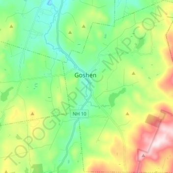
Nombre: Mapa topográfico Goshen, altitud, relieve.
Lugar: Goshen, Sullivan County, New Hampshire, 03752, United States (43.24895 -72.16550 43.34080 -72.06328)
Altitud media: 419 m
Altitud mínima: 249 m
Altitud máxima: 765 m
The long ridge of Mount Sunapee occupies the eastern edge of town. The highest point in Goshen is an unnamed knob on the ridge (near Goves Mountain) where the elevation reaches 2,529 feet (771 m) above sea level.