
Mapa topográfico Lake Coeur d'Alene
Mapa interactivo
Haga clic en el mapa para ver la altitud.
Acerca de este mapa
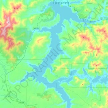
Nombre: Mapa topográfico Lake Coeur d'Alene, altitud, relieve.
Altitud media: 827 m
Altitud mínima: 640 m
Altitud máxima: 1.579 m
The lake's elevation varies from 2,128 feet (649 m) above sea level in the summer to up to 7 feet (2.1 m) lower in the winter, controlled by the Post Falls Dam 9 miles (14 km) below the lake on the Spokane River.