
Haz una donación
Mapa topográfico Fairfield
Haga clic en el mapa para ver la altitud.
Haz una donación
Acerca de este mapa
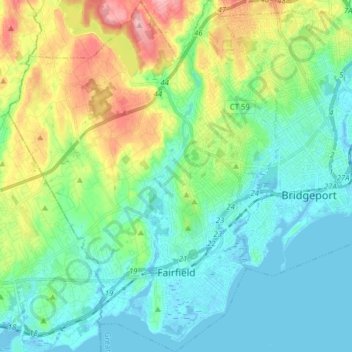
Nombre: Mapa topográfico Fairfield, altitud, relieve.
Altitud media: 37 m
Altitud mínima: -8 m
Altitud máxima: 138 m
Haz una donación
Otros mapas topográficos
Haga clic en un mapa para ver su topografía, su altitud y su relieve.
Oronoque
United States > Connecticut > Greater Bridgeport Planning Region > Stratford
Altitud media: 37 m
Southport
United States > Connecticut > Greater Bridgeport Planning Region > Fairfield
Altitud media: 11 m
Greenfield Hill
United States > Connecticut > Greater Bridgeport Planning Region > Fairfield
Altitud media: 53 m
Long Hill
United States > Connecticut > Greater Bridgeport Planning Region > Trumbull
Altitud media: 117 m
Haz una donación
Barn Hill
United States > Connecticut > Greater Bridgeport Planning Region > Monroe
Altitud media: 146 m
Long Hill
United States > Connecticut > Greater Bridgeport Planning Region > Trumbull
Altitud media: 117 m
Powells Hill
United States > Connecticut > Greater Bridgeport Planning Region > Easton
Altitud media: 87 m
Stratfield
United States > Connecticut > Greater Bridgeport Planning Region > Fairfield
Altitud media: 53 m
Haz una donación
Lordship Beach
United States > Connecticut > Greater Bridgeport Planning Region > Stratford > Lordship
Altitud media: 1 m