
Haz una donación
Mapa topográfico Great Stukeley
Haga clic en el mapa para ver la altitud.
Haz una donación
Acerca de este mapa
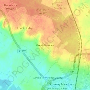
Nombre: Mapa topográfico Great Stukeley, altitud, relieve.
Altitud media: 32 m
Altitud mínima: 10 m
Altitud máxima: 53 m
Haz una donación
Otros mapas topográficos
Haga clic en un mapa para ver su topografía, su altitud y su relieve.
Haz una donación
Haz una donación
Hinchingbrooke Country Park
United Kingdom > England > Cambridgeshire > Huntingdonshire > Huntingdon > Brampton
Altitud media: 16 m
Haz una donación
Haz una donación
Bluntisham
United Kingdom > England > Cambridgeshire > Huntingdonshire > Bluntisham
Altitud media: 12 m
Haz una donación
Old Weston
United Kingdom > England > Cambridgeshire > Huntingdonshire > Old Weston
Altitud media: 65 m
Great Staughton
United Kingdom > England > Cambridgeshire > Huntingdonshire > Great Staughton
Altitud media: 43 m
Haz una donación
Holywell-cum-Needingworth
United Kingdom > England > Cambridgeshire > Huntingdonshire
Altitud media: 10 m
Haz una donación
Hail Weston
United Kingdom > England > Cambridgeshire > Huntingdonshire > Hail Weston
Altitud media: 31 m
Haz una donación
Hemingford Grey
United Kingdom > England > Cambridgeshire > Huntingdonshire > Hemingford Grey
Altitud media: 11 m
Haz una donación
Abbots Ripton
United Kingdom > England > Cambridgeshire > Huntingdonshire > Abbots Ripton
Altitud media: 38 m
Haz una donación
Haz una donación
Hartford Marina
United Kingdom > England > Cambridgeshire > Huntingdonshire > Wyton
Altitud media: 14 m
Haz una donación
Mill Pool
United Kingdom > England > Cambridgeshire > Huntingdonshire > Huntingdon
Altitud media: 14 m
Haz una donación
Kings Ripton
United Kingdom > England > Cambridgeshire > Huntingdonshire > Kings Ripton
Altitud media: 34 m
Haz una donación
Offord Cluny and Offord D'Arcy
United Kingdom > England > Cambridgeshire > Huntingdonshire > Offord Darcy
Altitud media: 31 m
Haz una donación
Bluntisham
United Kingdom > England > Cambridgeshire > Huntingdonshire > Bluntisham
Altitud media: 12 m
Haz una donación
Haz una donación
Haz una donación