
Mapa topográfico Churchill County
Mapa interactivo
Haga clic en el mapa para ver la altitud.
Acerca de este mapa
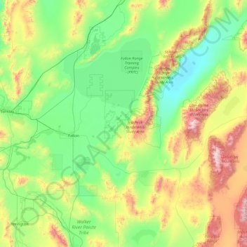
Nombre: Mapa topográfico Churchill County, altitud, relieve.
Lugar: Churchill County, Nevada, United States of America (39.07364 -119.22574 40.00304 -117.46018)
Altitud media: 1.476 m
Altitud mínima: 1.029 m
Altitud máxima: 3.027 m
The terrain of Churchill County consists of rugged mountainous ridges, dotted with lakes and ponds. The county's east and west sides are higher than the intermediate valley; its highest point around the county periphery is a ridge on the lower east boundary line, at 9,380' (2859m) ASL. The county has an area of 5,024 square miles (13,010 km2), of which 4,930 square miles (12,800 km2) is land and 94 square miles (240 km2) (1.9%) is water. The county's highest point is Desatoya Peak at 9,977' (3041m), while the most topographically prominent peak is Mount Augusta, at 9,970' (3039m) ASL.