
Haz una donación
Mapa topográfico Thrissur
Haga clic en el mapa para ver la altitud.
Haz una donación
Thrissur
Thrissur is the headquarters of Thrissur district, in the centre of the Indian state of Kerala. The city is 75 km north-east of Kochi, 133 km south-west of Coimbatore, 124 km south-east of Kozhikode and 151 km north of Changanacherry. The city is located in a hillock called Thekkinkadu Maidan which is the second highest point in city after the Vilangan Hills. The city has an average altitude of 2.83 metres above sea level.
Haz una donación
Acerca de este mapa
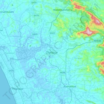
Nombre: Mapa topográfico Thrissur, altitud, relieve.
Lugar: Thrissur, Kerala, 680001, India (10.36701 76.05462 10.68701 76.37462)
Altitud media: 36 m
Altitud mínima: -6 m
Altitud máxima: 516 m
Haz una donación
Otros mapas topográficos
Haga clic en un mapa para ver su topografía, su altitud y su relieve.
Haz una donación
Kulam -Balakrishnan,Karamangattil, Chazhoor, Chetakulam
India > Kerala > Thrissur > Puthenpeedika
Altitud media: 6 m
Haz una donación
Haz una donación
Haz una donación
Haz una donación
Haz una donación