
Gracias por apoyar a este sitio ❤️
Haz una donación
Haz una donación
Mapa topográfico Great Bend
Haga clic en el mapa para ver la altitud.
Gracias por apoyar a este sitio ❤️
Haz una donación
Haz una donación
Great Bend
Great Bend is located at 38°21′52″N 98°45′53″W / 38.36444°N 98.76472°W / 38.36444; -98.76472 (38.3644567, -98.7648073) at an elevation of 1,850 feet (564 m). Located in central Kansas at the intersection of U.S. Route 281 and U.S. Route 56, Great Bend is 95 miles (153 km) northwest of Wichita, 235 miles (378 km) west-southwest of Kansas City, and 345 miles (555 km) east-southeast of Denver.
Gracias por apoyar a este sitio ❤️
Haz una donación
Haz una donación
Acerca de este mapa
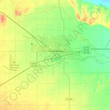
Nombre: Mapa topográfico Great Bend, altitud, relieve.
Lugar: Great Bend, Barton County, Kansas, 67530, United States (38.33027 -98.88497 38.38372 -98.69708)
Altitud media: 570 m
Altitud mínima: 549 m
Altitud máxima: 593 m
Gracias por apoyar a este sitio ❤️
Haz una donación
Haz una donación
Otros mapas topográficos
Haga clic en un mapa para ver su topografía, su altitud y su relieve.