
Haz una donación
Mapa topográfico Les Ulis
Haga clic en el mapa para ver la altitud.
Haz una donación
Les Ulis
The source of the minor river Rouillon (river) is in the neighbouring town of Villejust, close to the communal border. The lowest point of the town, at the point where it meets Bures-sur-Yvette, is at an altitude of 87m. Most of the town is situated at an average altitude of over 150m. Its highest point is at 170m. The land on which it is built consists of clay, sand and millstone.
Haz una donación
Acerca de este mapa
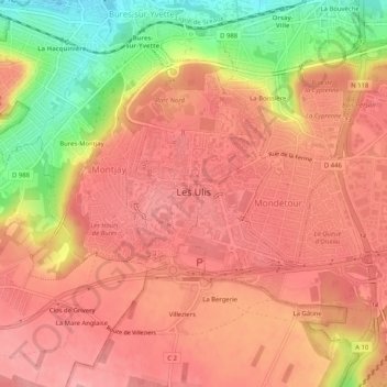
Nombre: Mapa topográfico Les Ulis, altitud, relieve.
Altitud media: 138 m
Altitud mínima: 60 m
Altitud máxima: 174 m
Haz una donación
Otros mapas topográficos
Haga clic en un mapa para ver su topografía, su altitud y su relieve.
Paris Basin
France > Ile-de-France > Essonne > Bièvres
The landscape is one of very broad valleys (flood plains), modest watershed hills and well-drained plateaux of comparatively little altitude. In the south-east and east the plain of Champagne and the Seuil de Bourgogne (Threshold of Burgundy) differential erosion of the strata has left low scarps with the dip…
Altitud media: 126 m