
Haz una donación
Mapa topográfico Tracy
Haga clic en el mapa para ver la altitud.
Haz una donación
Acerca de este mapa
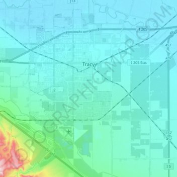
Nombre: Mapa topográfico Tracy, altitud, relieve.
Lugar: Tracy, San Joaquin County, California, United States (37.66056 -121.54902 37.77961 -121.38010)
Altitud media: 35 m
Altitud mínima: -2 m
Altitud máxima: 330 m
Haz una donación
Otros mapas topográficos
Haga clic en un mapa para ver su topografía, su altitud y su relieve.
Mountain House
United States > California > San Joaquin County
Mountain House lies on the foothills of the Diablo Range, and close to the Altamont Pass which is over 1,000 feet in elevation. It is on the border of Alameda and Contra Costa counties. According to the United States Census Bureau, the CDP covers an area of 3.2 square miles (8.3 km2), all of it land. The…
Altitud media: 22 m
Haz una donación
Peters
United States > California > San Joaquin County > Peters
Peters is a census-designated place in San Joaquin County, California. Peters sits at an elevation of 112 feet (34 m). The 2010 United States census reported Peters' population was 672.
Altitud media: 32 m
Lathrop
United States > California > San Joaquin County > Lathrop > Lathrop
Lathrop is located at 37°49′1″N 121°17′19″W / 37.81694°N 121.28861°W / 37.81694; -121.28861 (37.816904, -121.288633). The San Joaquin River is on the west side of Lathrop and has elevation of 20 feet (7 m).
Altitud media: 7 m
Haz una donación
The Homestead
United States > California > San Joaquin County > Stockton > The Homestead
Altitud media: 6 m
Haz una donación