
Haz una donación
Mapa topográfico Cedar Hill
Haga clic en el mapa para ver la altitud.
Haz una donación
Cedar Hill
The city is sometimes referred to as the "hill country of Dallas" (in comparison to the "hill country" surrounding Austin and San Antonio). The city is full of native eastern red cedar evergreen trees and stands at an elevation of about 800 feet (240 m) above sea level—the highest point in a straight line from the Red River at the Texas-Oklahoma border to the Gulf Coast.
Haz una donación
Acerca de este mapa
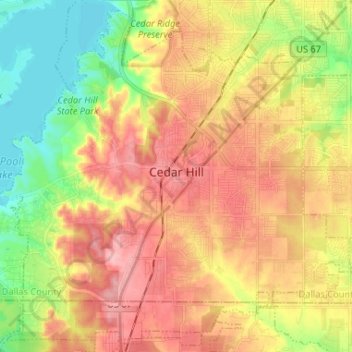
Nombre: Mapa topográfico Cedar Hill, altitud, relieve.
Lugar: Cedar Hill, Dallas County, Texas, 75104, United States (32.53492 -97.02123 32.63941 -96.89043)
Altitud media: 214 m
Altitud mínima: 156 m
Altitud máxima: 268 m
Haz una donación
Otros mapas topográficos
Haga clic en un mapa para ver su topografía, su altitud y su relieve.
Haz una donación
Haz una donación
Haz una donación
Haz una donación
Dallas
United States > Texas > Dallas County > Dallas
Dallas and its surrounding area are mostly flat. The city lies at elevations ranging from 450 to 550 feet (137 to 168 m) above sea level. The western edge of the Austin Chalk Formation, a limestone escarpment (also known as the "White Rock Escarpment"), rises 230 feet (70 m) and runs roughly north–south…
Altitud media: 158 m
Haz una donación
Haz una donación