
Haz una donación
Mapa topográfico lac Seul
Haga clic en el mapa para ver la altitud.
Haz una donación
lac Seul
Lac Seul is a large, crescent shaped reservoir in Kenora District, northwestern Ontario, Canada. It is approximately 241 km (150 mi) long. It has a maximum (regulated) depth of 47.2 m, with a surface elevation of 357 m above sea level. Its level is raised in the summer and then drawn down in the winter months to reach points of as low as 16 feet below the maximum level. It is the second largest body of water entirely within the province of Ontario (Lake Nipigon being first). The lake consists of open water bays, narrow channels, and islands. It is a relatively shallow lake with many rock shoals. This provides a good habitat for walleye (also known as "yellow pickerel") and northern pike as well as yellow perch. During the Lac Seul project of 1968-1972 no muskelunge were noted in the catches of research nets set over those years. Significant numbers of whitefish, tullibee, burbot and cisco were noted as well although they infrequently were noted in the sport fishery. Lac Seul is noted for offering some of the best fishing in Ontario.
Haz una donación
Acerca de este mapa
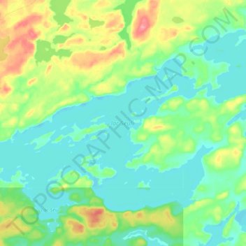
Nombre: Mapa topográfico lac Seul, altitud, relieve.
Altitud media: 374 m
Altitud mínima: 351 m
Altitud máxima: 431 m
Haz una donación
Otros mapas topográficos
Haga clic en un mapa para ver su topografía, su altitud y su relieve.
Haz una donación
Cardinal (Lac) Lake
Canada > Ontario > Kenora District > Unorganized Kenora District
Altitud media: 392 m
Hudson Bay Lowlands
Canada > Ontario > Kenora District > Unorganized Kenora District
Altitud media: 17 m
Haz una donación
Haz una donación
Haz una donación
Haz una donación
Haz una donación
Haz una donación
Haz una donación
Haz una donación
Haz una donación
Little Boulder Lake
Canada > Ontario > Kenora District > Unorganized Kenora District
Altitud media: 359 m
Haz una donación