
Gracias por apoyar a este sitio ❤️
Haz una donación
Haz una donación
Mapa topográfico Creekside Village
Haga clic en el mapa para ver la altitud.
Gracias por apoyar a este sitio ❤️
Haz una donación
Haz una donación
Acerca de este mapa
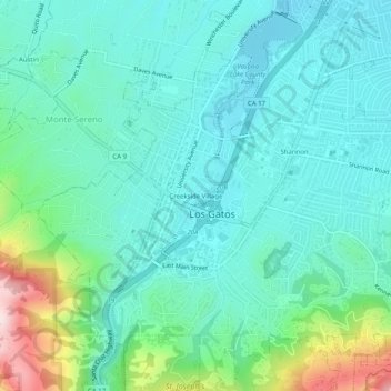
Nombre: Mapa topográfico Creekside Village, altitud, relieve.
Altitud media: 166 m
Altitud mínima: 79 m
Altitud máxima: 486 m
Gracias por apoyar a este sitio ❤️
Haz una donación
Haz una donación
Otros mapas topográficos
Haga clic en un mapa para ver su topografía, su altitud y su relieve.
Vasona Lake County Park
United States > California > Santa Clara County > Los Gatos > Shannon
Altitud media: 109 m
Lexington Reservoir County Park
United States > California > Santa Clara County > Los Gatos
The reservoir is in the foothills of the Santa Cruz Mountains, at an elevation of 645 feet (197 m).
Altitud media: 330 m