
Haz una donación
Mapa topográfico Solan
Haga clic en el mapa para ver la altitud.
Haz una donación
Solan
Solan is a city in the Indian state of Himachal Pradesh and the district headquarters of Solan district. It is located 45.5 kilometres (28 mi) south of the state capital, Shimla. Solan has an average elevation of 1,550 metres (5,090 ft). The city is situated between Chandigarh (joint capital of Punjab and Haryana) and Shimla (state capital) on the Kalka-Shimla National Highway-5. The narrow-gauge Kalka-Shimla railway passes through Solan. Located on the Punjab-Himachal Border, Solan is nestled in the Shivalik hills of the Himalayas.
Haz una donación
Acerca de este mapa
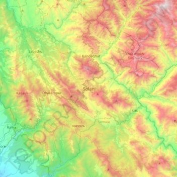
Nombre: Mapa topográfico Solan, altitud, relieve.
Lugar: Solan, Himachal Pradesh, 173212, India (30.74776 76.94236 31.06776 77.26236)
Altitud media: 1.312 m
Altitud mínima: 428 m
Altitud máxima: 2.558 m
Haz una donación