
Mapa topográfico Puig Major
Mapa interactivo
Haga clic en el mapa para ver la altitud.
Acerca de este mapa
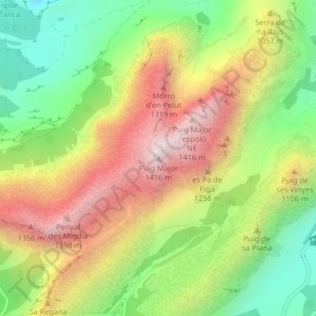
Nombre: Mapa topográfico Puig Major, altitud, relieve.
Altitud media: 949 m
Altitud mínima: 510 m
Altitud máxima: 1.444 m
Puig Major is the highest peak on the Spanish island of Majorca. With an elevation of 1,436 m (4,711 ft) above sea level. It is situated in the Serra de Tramuntana mountains. As the mountain is located in a military zone, the neighbouring peak Puig de Massanella (1,364 m) is considered the highest accessible summit on the island.
Otros mapas topográficos
Haga clic en un mapa para ver su topografía, su altitud y su relieve.
Lluc
Spain > Balearic Islands > Serra de Tramuntana > Escorca
Lluc, Escorca, Serra de Tramuntana, Balearic Islands, 07315, Spain
Altitud media: 603 m