
Haz una donación
Mapa topográfico Moor
Haga clic en el mapa para ver la altitud.
Haz una donación
Acerca de este mapa
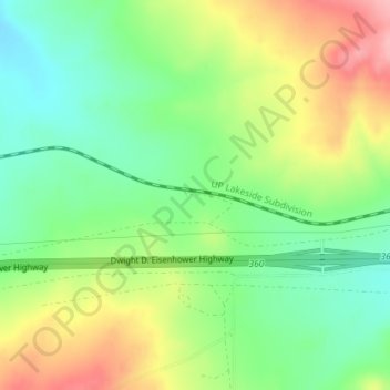
Nombre: Mapa topográfico Moor, altitud, relieve.
Lugar: Moor, Elko County, Nevada, United States (41.10715 -114.82504 41.12715 -114.80504)
Altitud media: 1.889 m
Altitud mínima: 1.837 m
Altitud máxima: 1.964 m
Haz una donación
Otros mapas topográficos
Haga clic en un mapa para ver su topografía, su altitud y su relieve.
Ruby Mountains
United States > Nevada > Elko County
The Ruby Mountains (Shoshoni: 'Duka Doya', meaning “Snowcapped”) are a mountain range, primarily located within Elko County with a small extension into White Pine County, in Nevada, United States. Most of the range is included within the Humboldt-Toiyabe National Forest. The range reaches a maximum…
Altitud media: 1.962 m
Haz una donación
Wells
United States > Nevada > Elko County
According to the United States Census Bureau, the city has a total area of 6.9 square miles (18 km2), all land, at an elevation of 5,630 feet (1,720 m).
Altitud media: 1.744 m
Wells
United States > Nevada > Elko County
According to the United States Census Bureau, the city has a total area of 6.9 square miles (18 km2), all land, at an elevation of 5,630 feet (1,720 m).
Altitud media: 1.744 m
Haz una donación
Carlin
United States > Nevada > Elko County
Carlin is a city in Elko County of northeast Nevada, United States, and 23 miles (37 km) west of the city of Elko. As of the 2010 census, its population was 2,368, up from 2,161 at the 2000 census. Carlin sits along Interstate 80 at an elevation of approximately 4,900 feet (1,500 m). The city was named for…
Altitud media: 1.522 m