
Haz una donación
Mapa topográfico Çubuk
Haga clic en el mapa para ver la altitud.
Haz una donación
Çubuk
Çubuk is a municipality and district of Ankara Province, Turkey. Its area is 1,198 km2, and its population is 95,449 (2022). Çubuk is in a flat plain 35 km north of the city of Ankara, where Ankara airport is located. Its elevation is 1,000 m (3,281 ft).
Haz una donación
Acerca de este mapa
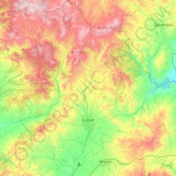
Nombre: Mapa topográfico Çubuk, altitud, relieve.
Lugar: Çubuk, Ankara, Central Anatolia Region, 06760, Turkey (40.09278 32.80479 40.54564 33.27816)
Altitud media: 1.267 m
Altitud mínima: 782 m
Altitud máxima: 2.035 m
Haz una donación
Otros mapas topográficos
Haga clic en un mapa para ver su topografía, su altitud y su relieve.
Ankara
Ankara has a cold semi-arid climate (Köppen climate classification: BSk). Under the Trewartha climate classification, Ankara has a temperate humid continental climate (Dc). Due to its elevation and inland location, Ankara has cold and snowy winters, and hot and dry summers. Rainfall occurs mostly during the…
Altitud media: 1.082 m
Ankara
Ankara has a cold semi-arid climate under the Köppen climate classification (BSk), while under the Trewartha climate classification, the city is classified as humid continental (Dc). Due to its elevation and inland location, Ankara has cold and snowy winters, and hot and dry summers. Rainfall occurs mostly…
Altitud media: 1.082 m
Haz una donación
Haz una donación
Ankara
Ankara has a cold semi-arid climate under the Köppen climate classification (BSk), while under the Trewartha climate classification, the city is classified as humid continental (Dc). Due to its elevation and inland location, Ankara has cold and snowy winters, and hot and dry summers. Rainfall occurs mostly…
Altitud media: 1.082 m