Geolocalizar

Mapa topográfico Ramsgate

Haga clic en el mapa para ver la altitud.

Ramsgate

In 2017 Ramsgate was chosen as one of the first ten Heritage Action Zones (HAZ) by Historic England, with the aim of stimulating economic growth by taking advantage of Ramsgate's historic environment. Part of this project included a Historic Landscape Characterisation Study which assessed and mapped the patterns of historic character in the town, using geological and topographical surveys, and covering aspects from the Neolithic, medieval, Georgian, Victorian, and through to the First and Second World War periods.

Wikipedia (CC-BY-SA 3.0)

Acerca de este mapa

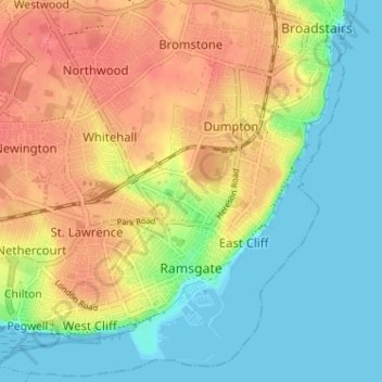
Nombre: Mapa topográfico Ramsgate, altitud, relieve.

Lugar: Ramsgate, Thanet, Kent, England, United Kingdom (51.32210 1.37687 51.36087 1.44107)

Altitud media: 25 m

Altitud mínima: 0 m

Altitud máxima: 55 m

Otros mapas topográficos

Haga clic en un mapa para ver su topografía, su altitud y su relieve.

Ebbsfleet

United Kingdom > England > Kent > Thanet

Altitud media: 4 m

Broadstairs

United Kingdom > England > Kent > Thanet

Altitud media: 14 m

Flete

United Kingdom > England > Kent > Thanet > Manston

Altitud media: 39 m

Hoo

United Kingdom > England > Kent > Thanet > Minster

Altitud media: 16 m

Pegwell Bay

United Kingdom > England > Kent > Thanet > Cliffsend

Altitud media: 9 m

Ebbsfleet

United Kingdom > England > Kent > Thanet

Altitud media: 4 m

Minnis Bay

United Kingdom > England > Kent > Thanet

Altitud media: 6 m

Broadstairs

United Kingdom > England > Kent > Thanet

Altitud media: 14 m

Dane Park

United Kingdom > England > Kent > Thanet > Margate

Altitud media: 18 m

Haine

United Kingdom > England > Kent > Thanet > Ramsgate > Westwood

Altitud media: 42 m

Way

United Kingdom > England > Kent > Thanet > Minster > Way

Altitud media: 23 m