
Mapa topográfico Lac Philippe
Mapa interactivo
Haga clic en el mapa para ver la altitud.
Acerca de este mapa
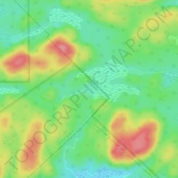
Nombre: Mapa topográfico Lac Philippe, altitud, relieve.
Altitud media: 384 m
Altitud mínima: 345 m
Altitud máxima: 438 m
Otros mapas topográficos
Haga clic en un mapa para ver su topografía, su altitud y su relieve.
Mont Gabriel
Canada > Quebec > Les Pays-d'en-Haut > Sainte-Adèle
Mont Gabriel, Sainte-Adèle, Les Pays-d'en-Haut, Laurentides, Quebec, J8B 2J8, Canada
Altitud media: 248 m
Lac à Bélair
Canada > Quebec > Les Pays-d'en-Haut > Sainte-Adèle
Lac à Bélair, Sainte-Adèle, Les Pays-d'en-Haut, Laurentides, Quebec, Canada
Altitud media: 314 m
Glen Wexford
Canada > Quebec > Les Pays-d'en-Haut > Sainte-Adèle
Glen Wexford, Sainte-Adèle, Les Pays-d'en-Haut, Laurentides, Quebec, J8B 2N6, Canada
Altitud media: 296 m