Geolocalizar

Mapa topográfico Mokokchung

Haga clic en el mapa para ver la altitud.

Acerca de este mapa

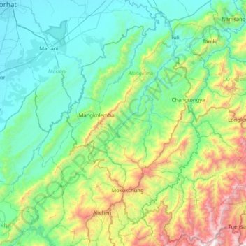
Nombre: Mapa topográfico Mokokchung, altitud, relieve.

Lugar: Mokokchung, Nagaland, India (26.19380 94.28956 26.76546 94.75764)

Altitud media: 561 m

Altitud mínima: 89 m

Altitud máxima: 2.272 m

Otros mapas topográficos

Haga clic en un mapa para ver su topografía, su altitud y su relieve.

Ralan

India > Nagaland > Ralan

Altitud media: 540 m

Chessore Village

India > Nagaland > Chessore

Altitud media: 1.325 m

Mount Saramati

India > Nagaland > Khongsa

Altitud media: 3.333 m

Khonoma

India > Nagaland > Sechu-Zubza

Altitud media: 1.627 m

Medziphema

India > Nagaland > Medziphema

Altitud media: 458 m

Shokuvi

India > Nagaland > Dhansiripar

Altitud media: 217 m

Lozaphohemi

India > Nagaland > Phek Sadar

Altitud media: 1.230 m

Jotsoma

India > Nagaland > Sechu-Zubza

Altitud media: 1.346 m

Sirhi Angami

India > Nagaland > Medziphema

Altitud media: 440 m

Agri Expo

India > Nagaland > Chumukedima

Altitud media: 169 m

Chumukedima

India > Nagaland > Chumukedima

Altitud media: 251 m

Rajbari

India > Nagaland > Chumukedima

Altitud media: 162 m

Nihokhu

India > Nagaland > Nihokhu

Altitud media: 214 m

Piphema

India > Nagaland > Medziphema

Altitud media: 854 m

Changki

India > Nagaland > Mangkolemba

Altitud media: 588 m

Jalukie

India > Nagaland > Jalukie

Altitud media: 338 m

Enhulumi

India > Nagaland > Chizami

Altitud media: 1.396 m

Phek

India > Nagaland > Phek Sadar

Altitud media: 1.233 m

Medziphema

India > Nagaland > Medziphema

Altitud media: 458 m

Kohima

India > Nagaland > Kohima Sadar

Kohima (/koʊˈhiːmə/ ; Angami Naga: Kewhira (IPA: [ˈkɛʍɪɻə])) is the capital of the North East Indian state of Nagaland. With a resident population of almost 100,000, it is the second largest city in the state. Kohima constitutes both a district and a municipality. The municipality covers 20 km2 (7.7…

Altitud media: 1.425 m

Phesama

India > Nagaland > Jakhama

Altitud media: 1.534 m

Kohima

India > Nagaland > Kohima Sadar

Kohima (/koʊˈhiːmə/ ; Angami Naga: Kewhira (IPA: [ˈkɛʍɪɻə]) is the capital of the Indian state of Nagaland. With a resident population of almost 100,000, it is the second largest city in the state. Kohima constitutes both a district and a municipality. The municipality covers 20 km2 (7.7 sq mi). The…

Altitud media: 1.425 m

Kanubari

India > Nagaland > Mon

Altitud media: 154 m

Yimpang

India > Nagaland > Noklak

Altitud media: 2.034 m

Dimapur

India > Nagaland > Dimapur Sadar

Altitud media: 204 m

Doyang

India > Nagaland > Sanis > Sanis

Altitud media: 552 m

Viswema

India > Nagaland > Jakhama > Viswema

Altitud media: 1.530 m

Kohīma

India > Nagaland > Kohīma

Altitud media: 1.001 m

Kigwema Town

India > Nagaland > Jakhama

Altitud media: 1.688 m

town square

India > Nagaland > Chizami > town square

Altitud media: 1.324 m

Rangapahar WLS

India > Nagaland > Chumukedima

Altitud media: 159 m