
Mapa topográfico Sawmill Creek
Mapa interactivo
Haga clic en el mapa para ver la altitud.
Acerca de este mapa
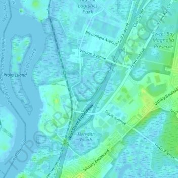
Nombre: Mapa topográfico Sawmill Creek, altitud, relieve.
Altitud media: 3 m
Altitud mínima: -4 m
Altitud máxima: 14 m
Otros mapas topográficos
Haga clic en un mapa para ver su topografía, su altitud y su relieve.
New York County
United States > New York > New York
New York County, New York, United States
Altitud media: 16 m
Manhattan Island
United States > New York > New York
Manhattan Island, New York, United States
Altitud media: 17 m
Willets Point
United States > New York > New York
Willets Point, Queens, New York, 11359, United States
Altitud media: 2 m
Brooklyn
United States > New York > New York
Brooklyn, Kings County, New York, United States
Altitud media: 9 m
Queens County
United States > New York > New York
Queens County, New York, United States
Altitud media: 11 m
Staten Island
United States > New York > New York
Staten Island, New York, United States
Altitud media: 11 m
Little Italy
United States > New York > New York
Little Italy, Manhattan Community Board 2, Manhattan, New York County, New York, 10012-3332, United States
Altitud media: 14 m
Bronx County
United States > New York > New York
Bronx County, The Bronx, New York, United States
Altitud media: 21 m